Post by teson1 on Sept 3, 2013 20:02:00 GMT -5
Here's a suggestion for a next race.
Short distance, 127 nm, but 8 legs. May be too much.
The last two legs might be proposed out of challenge: As suggestions, but will not be included in the score. (?)
Or may be completely dropped.
***************
This race takes us to Idaho's scenic Frank Church River of No Return wilderness with a mix of backcountry airstrips as challenging as they get - short (down to 1100 ft), high altitude (up to 6500 ft), located in deep canyons, difficult approaches, and at some no go-around is possible. You have to get it right the first time.
Be sure to review the landing strips before take-off and select a plane that can get in there.
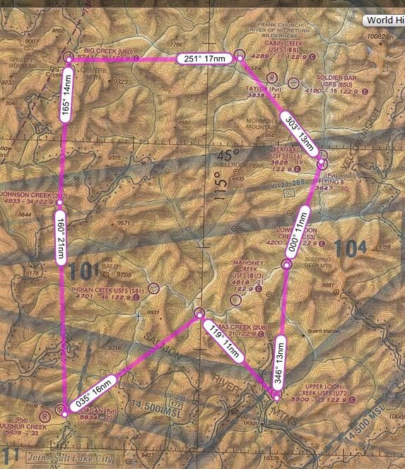
Leg 1
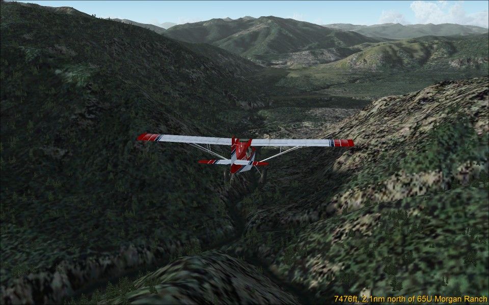
Distance: 21 nm
Depart: 02ID Morgan Ranch
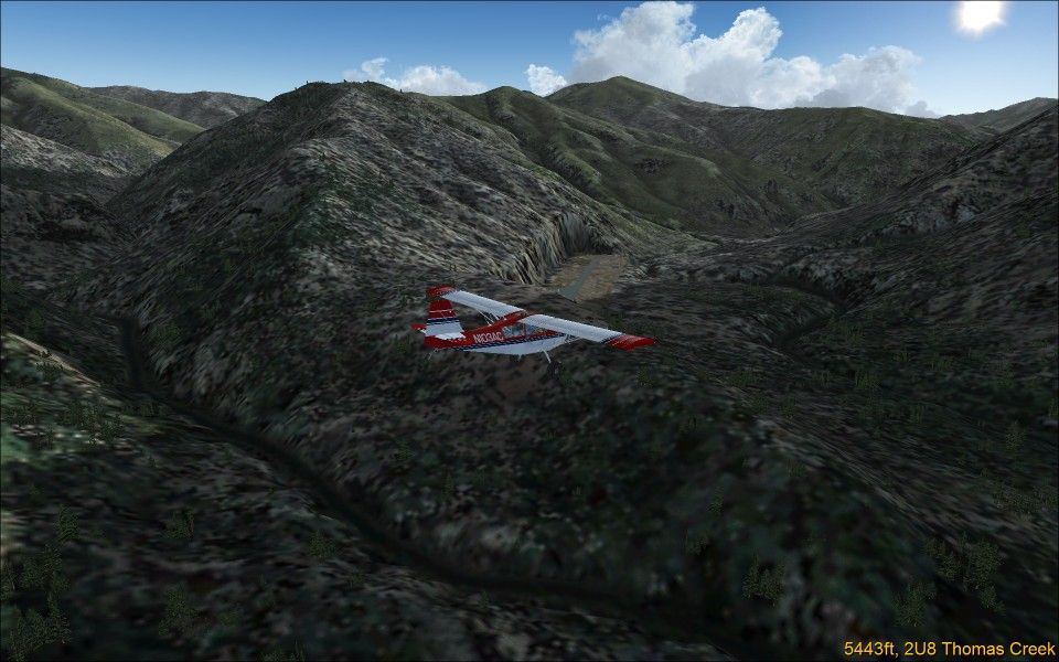
Arrive: 2U8 Thomas Creek
Map Link: skyvector.com/?ll=44.601242744811316,-115.25390489541473&chart=2&zoom=1&plan=A.K1.02ID:G.44.76744767345126,-115.09830859210154:A.K1.2U8
This leg takes us along the winding Middle Fork of the Salmon River from Morgan Ranch past Indian Creek strip to Thomas Creek, which appears just at the last moment when rounding the last river bend.
Maximum altitude: 6500 ft
Leg 2
Distance: 11 nm
Depart: 2U8 Thomas Creek
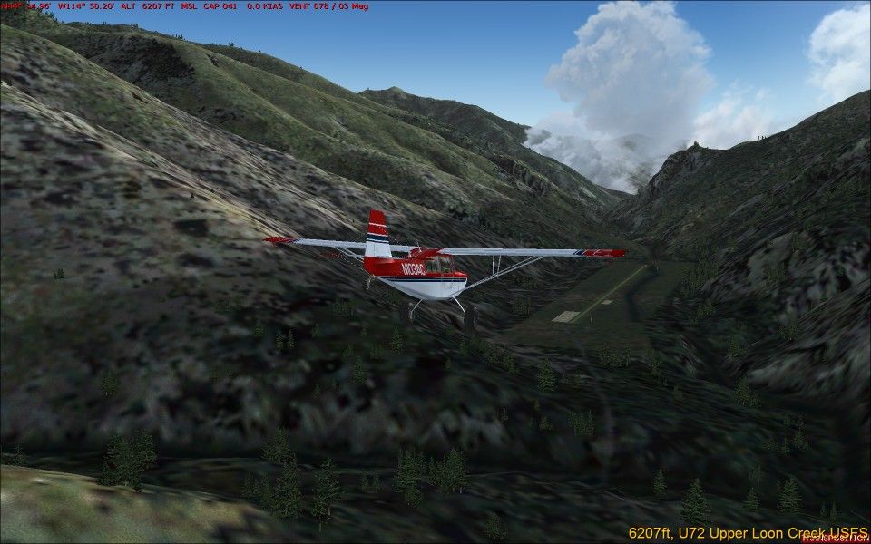
Arrive: U72 Upper Loon Creek USFS
Map Link: skyvector.com/?ll=44.68394788836196,-114.9417630059971&chart=2&zoom=1&plan=A.K1.2U8:A.K1.U72
Fly to Upper Loon Creek by whichever route you wish. You may select the direct hop over the ridge, but beware, there's a steep dive to the strip down in the canyon.
Maximum altitude: none
Leg 3
Distance: 15 nm
Depart: U72 Upper Loon Creek USFS
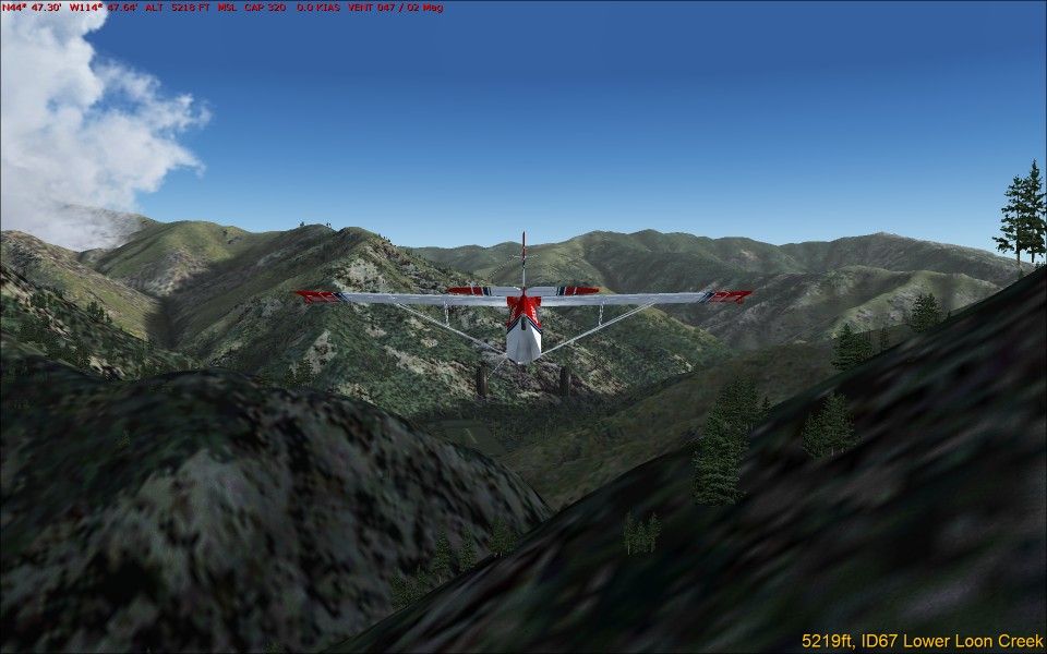
Arrive: ID67 Lower Loon Creek
Map Link: skyvector.com/?ll=44.716203528747684,-114.79272027069275&chart=2&zoom=1&plan=A.K1.U72:G.44.6642756809397,-114.7339032595473:G.44.74339484645026,-114.8175651341688:A.K1.C53
Fly down the spectacular winding steep canyon to the 1100 ft strip of Lower Loon Creek. Beware, depending on your scenery addons the approach may be difficult and there may be no go-around possible.
Maximum altitude: 6500 ft
Leg 4
Distance: 11 nm
Depart: ID67 Lower Loon Creek
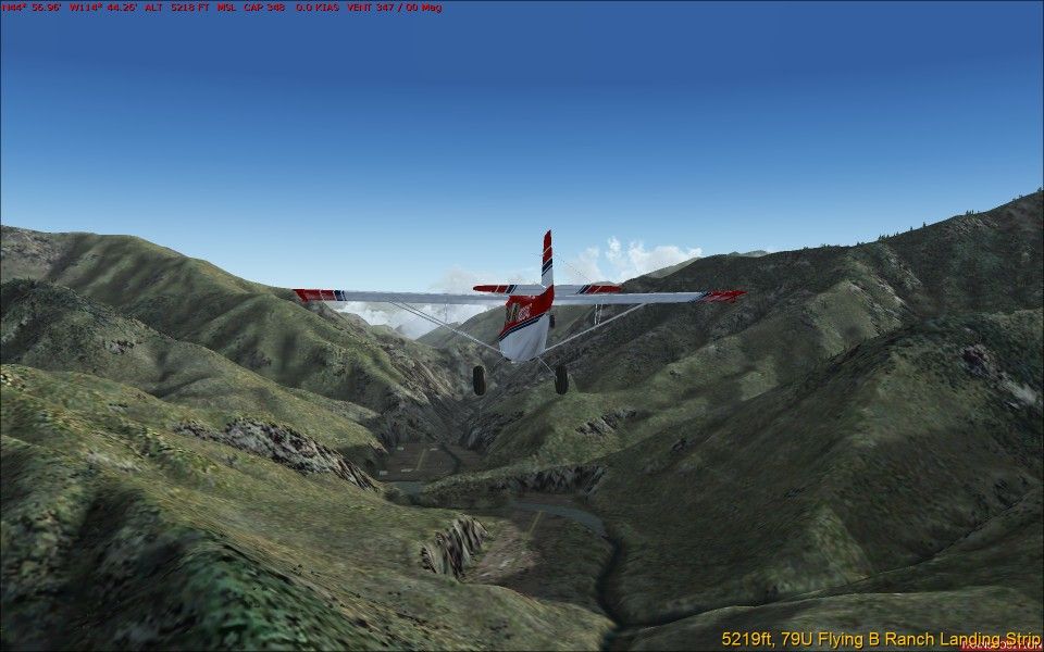
Arrive: U54 Bernard USFS
Map Link: skyvector.com/?ll=44.900671170011805,-114.72410638176991&chart=2&zoom=1&plan=A.K1.C53:A.K1.U54
This is a short flight along the river to the easy (but quite short) Bernard USFS landing strip.
Low flying challenge: Hug the ground as close as possible.
The three flyers with the lowest average flight altitude will receive a 20%, 10% or 5% bonus. Lowest average flight altitude is taken from the Duenna log.
Maximum altitude: none
Leg 5
Distance: 17 nm
Depart: U54 Bernard USFS
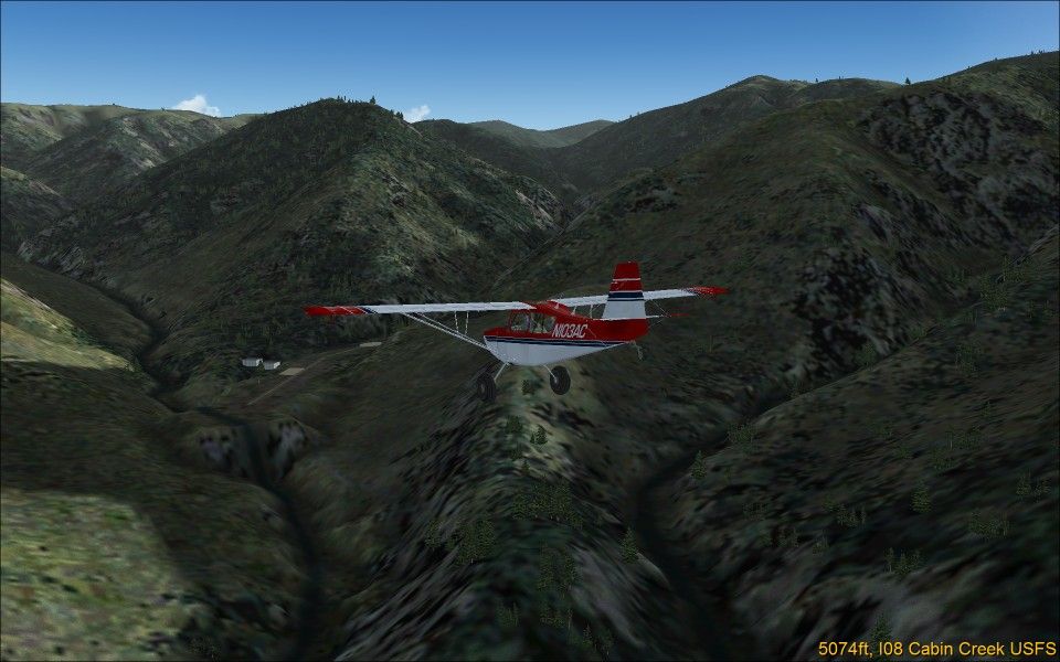
Arrive: I08 Cabin Creek USFS
Map Link: skyvector.com/?ll=45.03432947994878,-114.8182392140939&chart=2&zoom=1&plan=A.K1.U54:G.45.09181760749694,-114.73051645569325:G.45.11874239601754,-114.92268850961261:A.K1.I08
This leg continues down the Middle Fork of the Salmon River, and then turns into Big Creek for Cabin Creek strip. Beware, this strip is short, with a bend in the middle (FSX), and strictly one-way. No go-around possible.
Maximum altitude: 6500 ft
Leg 6
Distance: 17 nm
Depart: I08 Cabin Creek USFS
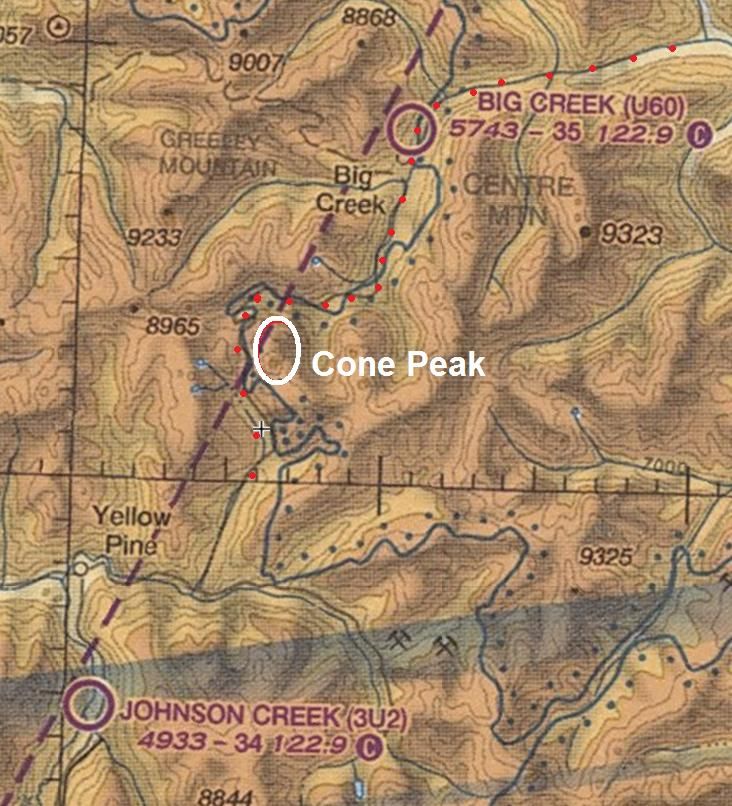
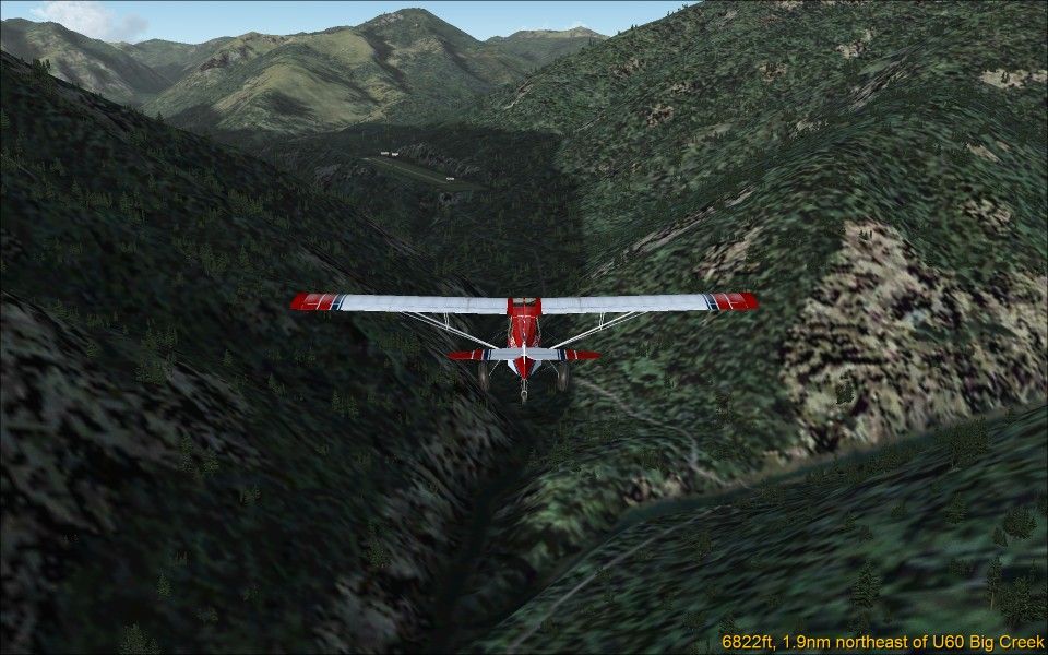
Arrive: U60 Big Creek
Map Link: skyvector.com/?ll=45.22347664137311,-115.1790870003314&chart=2&zoom=1&plan=A.K1.I08:G.45.13042417109844,-114.97278991093006:G.45.17222402243258,-115.17807810068692:A.K1.U60
By the standards of the last legs this is an easy one - once you've managed to take off from Cabin Creek. Fly up Big Creek to Big Creek strip.
Maximum altitude: 7000 ft
Leg 7
Distance: 14 nm
Depart: U60 Big Creek
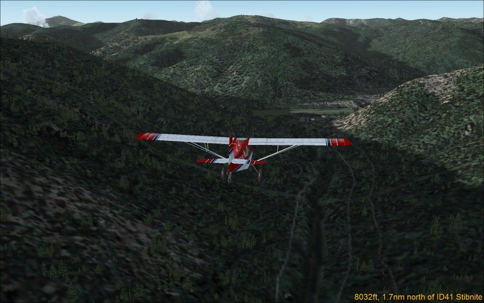
Arrive: ID41 Stibnite
Map Link: skyvector.com/?ll=45.033565328504885,-115.29841711054978&chart=2&zoom=1&plan=A.K1.U60:A.K1.ID41
This is a leisurely trip to enjoy the scenery from above. But at the end that airstrip is way down in the valley.
Maximum altitude: none
Leg 8
Distance: 21 nm
Depart: ID41 Stibnite
Arrive: 02ID Morgan Ranch
Map Link: skyvector.com/?ll=44.621214728363036,-115.32656584733341&chart=2&zoom=2&plan=A.K1.ID41:A.K1.02ID
Another leisurely trip to loop the loop.
Maximum altitude: none
Additional Course Info:
FS-Duenna Event Name: BPRL 2013 Race
FS-Duenna Event Log:
Skyvector Sectional: skyvector.com/?ll=44.74359819830444,-115.13571675013998&chart=2&zoom=3&plan=A.K1.02ID:A.K1.2U8:A.K1.U72:A.K1.C53:A.K1.U54:A.K1.I08:A.K1.U60:A.K1.ID41:A.K1.02ID
Short distance, 127 nm, but 8 legs. May be too much.
The last two legs might be proposed out of challenge: As suggestions, but will not be included in the score. (?)
Or may be completely dropped.
***************
This race takes us to Idaho's scenic Frank Church River of No Return wilderness with a mix of backcountry airstrips as challenging as they get - short (down to 1100 ft), high altitude (up to 6500 ft), located in deep canyons, difficult approaches, and at some no go-around is possible. You have to get it right the first time.
Be sure to review the landing strips before take-off and select a plane that can get in there.

Leg 1
Distance: 21 nm
Depart: 02ID Morgan Ranch
Arrive: 2U8 Thomas Creek
Map Link: skyvector.com/?ll=44.601242744811316,-115.25390489541473&chart=2&zoom=1&plan=A.K1.02ID:G.44.76744767345126,-115.09830859210154:A.K1.2U8
This leg takes us along the winding Middle Fork of the Salmon River from Morgan Ranch past Indian Creek strip to Thomas Creek, which appears just at the last moment when rounding the last river bend.
Maximum altitude: 6500 ft
Leg 2
Distance: 11 nm
Depart: 2U8 Thomas Creek
Arrive: U72 Upper Loon Creek USFS
Map Link: skyvector.com/?ll=44.68394788836196,-114.9417630059971&chart=2&zoom=1&plan=A.K1.2U8:A.K1.U72
Fly to Upper Loon Creek by whichever route you wish. You may select the direct hop over the ridge, but beware, there's a steep dive to the strip down in the canyon.
Maximum altitude: none
Leg 3
Distance: 15 nm
Depart: U72 Upper Loon Creek USFS
Arrive: ID67 Lower Loon Creek
Map Link: skyvector.com/?ll=44.716203528747684,-114.79272027069275&chart=2&zoom=1&plan=A.K1.U72:G.44.6642756809397,-114.7339032595473:G.44.74339484645026,-114.8175651341688:A.K1.C53
Fly down the spectacular winding steep canyon to the 1100 ft strip of Lower Loon Creek. Beware, depending on your scenery addons the approach may be difficult and there may be no go-around possible.
Maximum altitude: 6500 ft
Leg 4
Distance: 11 nm
Depart: ID67 Lower Loon Creek
Arrive: U54 Bernard USFS
Map Link: skyvector.com/?ll=44.900671170011805,-114.72410638176991&chart=2&zoom=1&plan=A.K1.C53:A.K1.U54
This is a short flight along the river to the easy (but quite short) Bernard USFS landing strip.
Low flying challenge: Hug the ground as close as possible.
The three flyers with the lowest average flight altitude will receive a 20%, 10% or 5% bonus. Lowest average flight altitude is taken from the Duenna log.
Maximum altitude: none
Leg 5
Distance: 17 nm
Depart: U54 Bernard USFS
Arrive: I08 Cabin Creek USFS
Map Link: skyvector.com/?ll=45.03432947994878,-114.8182392140939&chart=2&zoom=1&plan=A.K1.U54:G.45.09181760749694,-114.73051645569325:G.45.11874239601754,-114.92268850961261:A.K1.I08
This leg continues down the Middle Fork of the Salmon River, and then turns into Big Creek for Cabin Creek strip. Beware, this strip is short, with a bend in the middle (FSX), and strictly one-way. No go-around possible.
Maximum altitude: 6500 ft
Leg 6
Distance: 17 nm
Depart: I08 Cabin Creek USFS
Arrive: U60 Big Creek
Map Link: skyvector.com/?ll=45.22347664137311,-115.1790870003314&chart=2&zoom=1&plan=A.K1.I08:G.45.13042417109844,-114.97278991093006:G.45.17222402243258,-115.17807810068692:A.K1.U60
By the standards of the last legs this is an easy one - once you've managed to take off from Cabin Creek. Fly up Big Creek to Big Creek strip.
Maximum altitude: 7000 ft
Leg 7
Distance: 14 nm
Depart: U60 Big Creek
Arrive: ID41 Stibnite
Map Link: skyvector.com/?ll=45.033565328504885,-115.29841711054978&chart=2&zoom=1&plan=A.K1.U60:A.K1.ID41
This is a leisurely trip to enjoy the scenery from above. But at the end that airstrip is way down in the valley.
Maximum altitude: none
Leg 8
Distance: 21 nm
Depart: ID41 Stibnite
Arrive: 02ID Morgan Ranch
Map Link: skyvector.com/?ll=44.621214728363036,-115.32656584733341&chart=2&zoom=2&plan=A.K1.ID41:A.K1.02ID
Another leisurely trip to loop the loop.
Maximum altitude: none
Additional Course Info:
FS-Duenna Event Name: BPRL 2013 Race
FS-Duenna Event Log:
Skyvector Sectional: skyvector.com/?ll=44.74359819830444,-115.13571675013998&chart=2&zoom=3&plan=A.K1.02ID:A.K1.2U8:A.K1.U72:A.K1.C53:A.K1.U54:A.K1.I08:A.K1.U60:A.K1.ID41:A.K1.02ID